Geography of Lafayette, Louisiana
Lafayette, Louisiana is part of the Gulf Coastal Plain region of the United States and is located at coordinates 30°12′50″N 92°01′46″W. It has an elevation of 36 feet. One of the physical characteristics of the geography include many streams that drain the parish. The primary river that runs through the city is the Vermilion River. This river was formed by the confluence of a few small bayous, stretches about 70 miles long, and drains into the Gulf of Mexico. Most of Lafayette's landscape is urban; however its humid and subtropic climate during the summer allow it to house many species of birds, alligators, and fish. The winter season is mild. While Lafayette is situated in a geographic location that is overall relatively safe, the city is susceptible to flooding; hurricanes are also a common natural disaster.
Read article
Top Questions
AI generatedMore questions
Nearby Places
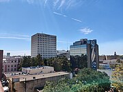
Lafayette, Louisiana
Consolidated city-parish in Louisiana, United States
University of Louisiana at Lafayette
Public university in Lafayette, Louisiana, US

Blackham Coliseum

Roman Catholic Diocese of Lafayette in Louisiana
Latin Catholic jurisdiction in the U.S.
McNaspy Stadium
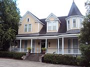
Elrose (Lafayette, Louisiana)
Historic house in Louisiana, United States

Yvette Girouard Field at Lamson Park
Softball park in Lafayette, Louisiana, US

Lafayette Charity Hospital
Hospital in Louisiana, United States